It looks like Microsoft listened to the community and plans on switching latitude and longitude ordering for WKT and WKB:
http://blogs.msdn.com/isaac/archive/2007/12/27/latitude-longitude-ordering.aspx
This change will only be for WKT and WKB. That does make some sense, since the ordering is related to the SRID which is not included in the WKT and WKB, thus making it impossible to decipher without any prior knowledge. It would still be nice if the two geometry models shared a more common interface for anything that is remotely similar, but this is a good start.
I’m actually starting to like working with the geography type (to begin with I hated the idea of having two different although similar geometry models). It’s fun to do buffers on points and see that they don’t look circular on a projected map, because they are, well… projected. Showing the same circles on a 3D globe reveals that they are in fact perfectly circular. It makes distance queries so much easier than for instance using this approach.

One thing that still bugs me about the geography datatype though… why is the linear unit type that is used for calculating area, length, buffers etc. declared as part of the SRID (which in this case is always geographic) ? This requires one to always first have to look up the linear unit in the spatial_ref_sys table for each returned row (since homogeneous SRIDs aren’t enforced on the table) and divide by the factor returned to ensure that we know the unit we get back. In my mind a linear unit should never be related to a geographic coordinate system. After all, that’s why we only define linear units in projected and geocentric coordinate systems where they makes sense.
It would be nice if the methods either took a unit type as input (although that would break with the common interface I just wished for) or simply just always outputs the results in SI units (then it would just be a matter of multiplying with a constant well-known conversion factor later if you want to display it in for instance miles, thus separating code from presentation). Luckily most of Katmai’s SR definitions use meters as default, but you never know if someone chose to change the conversion factors in the system table so you will always have to check first.
I've been playing with the spatial support of SQL Server 2008 today, but quickly hit two obstacles:
- How do I get data into the database.
- How do I visualize a query (apart from the Well-Known Text output).
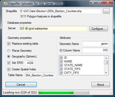
Surprisingly there aren't really any good (free) tools out there yet to upload for instance shapefiles to Katmai. I pulled out some old code I had lying around and threw a small tool together that can upload a shapefile to the database either as geometry or geography. Katmai is pretty picky when it comes to the geography datatype, so make sure your shapefiles contain valid geometry and has vertices in the valid domain, or use the geometry format. You can download the tool below.
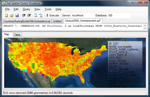
Next obstacle was visualizing the data. Playing with the spatial queries and not beeing able to see the results on a map quickly got boring. I haven't had a chance to play much with WPF, so I thought this was a good occation to play with it. Based on this MSDN article I managed to fairly quickly make a little tool that takes a SQL query as input and outputs the results in a WPF control. At the moment it only works with polylines and polygons - Points are simply ignored (tip: use STBuffer() on points to see them). It will look for the first column that contains a SqlGeometry or SqlGeography datatype and put that on the map. The remaining columns are shown in the box to the right when you hover over the shapes with the mouse.
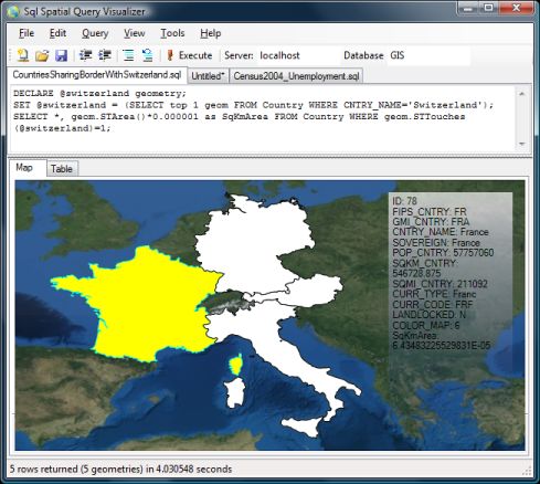
The two tools are not perfect in any way (and there's no bug tracking support here :-)), but they provide a quick way to play with the spatial queries. Both tools requires Windows Authentification to access the sql server and runs on .NET 3.5. Furthermore the query tool uses the Microsoft.SqlServer.Types.dll that comes with installing Katmai (to parse the results), so for now you'll need to run it from a computer that has Katmai installed.
Read more and download SqlSpatialTools
Now here's an interesting use of the spatial support in Microsofts SQL Server 2008: Battleship.
Using points, linestrings and hit-testing, Craig developed a small battleship game you can play by executing some stored procedures:
EXEX NewGame 'Craig'
EXEC Cheat 13,4
EXEC Shoot 13,4,1,1 -- Miss
EXEC Shoot 13,4,3,1 -- Hit
EXEC Shoot 13,4,3,2 -- Sunk
I'm not sure this was what Microsoft had in mind, but definitely nice work Craig!