SQL Server 2008 Spatial Tools

The SQL Spatial Tools consists of two tools to make it easy to get experience with the new spatial capabilities of SQL Server 2008 (click for more info) :
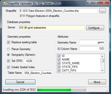
- Shape2SQL : Uploads ESRI Shapefiles to Microsoft SQL Server Spatial.
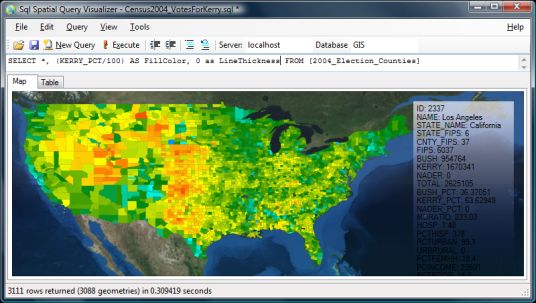
- SqlSpatial Query Tool : Queries MSSQL Server 2008 and displays geometry output on a WPF-based interactive map.
Requirements:
Bugs / Limitations / A Disclaimer
These tools are NOT meant for use in a production environment. Although a lot of people have managed to get the job done with these tools, there are cases where they will fail. Feel free to report issues, but don't count on me fixing them right away (if ever), but PLEASE read the FAQ first. Among the known issues are problems with case sensitive databases, problems reading shapefile attribute data in obscure encodings, auto-fixing invalid shapes, poor best guess on spatial indexes, etc. I'm sorry but I just don't have the time to test and fix all these edge cases. Use these tools at your own risk. They may well kill your pet kitten and render both your computer and you personally unbootable. If so, don't blame me as I'll deny everything. It's free software you found on the Internet, what did you expect? :-)
Lastly the source code is NOT available, so please don't ask for it, and the assemblies included are not to be used with any other application than the ones coming with this download.
Download
Related blogposts:
Recommended (and supported) alternatives
- ESRI MapIt. Dataloader + REST-based dataservice and client API's for visualisation from the world leader in GIS.
- Safe FME. The swiss army knife of spatial data conversions.